
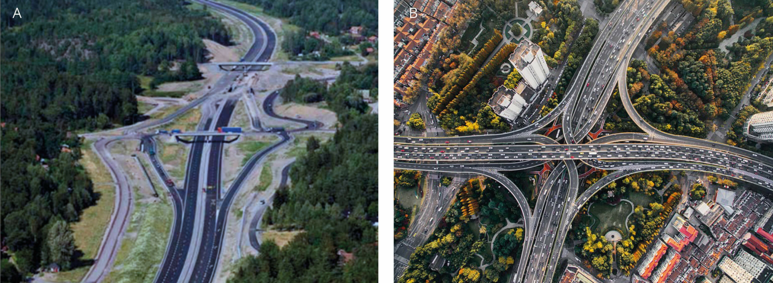
Transport infrastructure, such as roads, railways, canals, power lines, pipelines, airports and harbours, occupies a large amount of physical space, and leads to a direct and immediate loss of natural habitat. For example, a triple-lane motorway with verges, a hard shoulder and a median strip can easily span more than 50 metres in width (Figure 1.3.2). Thus, each kilometre of such highway takes up a space equivalent to about 10 football arenas (ca. 5 ha).
Across Europe, there are ~ 6.6 million km of roads from which ~ 410,000 km are motorways or other big infrastructure (data from 2019, Eurostat and other official sources). To this must be added ~ 510,000 km of railway. Roads and railroads combined cover an estimated 2% of the total land surface in Germany and nearly 4% in Belgium. This may appear small in comparison to other land cover types such as agriculture and forestry but given that infrastructure constitutes a network of transportation embedded in the surrounding land matrix, it practically occurs everywhere and thus has an influence on the entire landscape. On average, major public roads, and railways crisscross Europe at a density of almost 0.9 km per km2 of land according to the European Environment Agency (within the EU-27, data from 2016), ranging from about 0.03 to 0.27 km per km2 in Austria and Belgium, respectively.
In addition, when new highways or high-speed railways are constructed, associated infrastructure is often required to connect local roads, provide access points, build intersections, or grant access to local resources (Figure 1.3.2). These additional infrastructures contribute to direct habitat loss and disturb adjacent areas. The concept of ‘environmental footprint’ may hence be a more useful tool than what can be measured from direct habitat loss.
At local scale, the immediate occupation of space by infrastructure is certainly significant. Its impact can be partly avoided or offset by choosing alternative corridors for infrastructure, or by providing compensatory habitats nearby. However, this does not change the fact that the same space is lost for nature and people, and the same barrier, disturbance and pollution factors will affect the environment. Shifting new infrastructure only moves the impact elsewhere, preferably to less sensitive areas, but does not eliminate it entirely.
Efforts have been made to translate the spatial footprint of infrastructure to an economic footprint by multiplying the area consumed within its respective real-estate value. This approach easily yields high costs in attractive, valuable areas such as agriculture or urban development areas, but may fail to express the impact on less developed but environmentally important areas. Assessing the ‘environmental footprint’ is more challenging. One approach is to simply add the space allocated to transport to the area of vegetated land required to sequester the transport-related CO2 emissions (adding about 10-30 times the width of the road). The economic or environmental footprint provide attractive planning tools and have been a key concern in Environmental Impact Assessment (EIA). They may provide a useful, but only relative index in the comparison of alternative development scenarios. It is obvious, however, that these minimalistic approaches grossly underestimate the overall impact of infrastructure on biodiversity and ecosystems as they do not consider effects of the infrastructure in surrounding areas (see Section 1.3.5 – Habitat transformation and corridor effects).
Another comprehensive approach is the concept of infrastructure ‘effect zone’ (see Section 1.3.5 – Habitat transformation and corridor effects), that incorporates pollution and disturbance effects spreading into adjacent ecosystems, as well as the influence of barrier and mortality effects on nearby wildlife populations. The ‘effect zone’ may thus stretch for kilometres rather than the adjacent tens of metres. It has been estimated that transport infrastructure in the USA directly affects an area that is more than 19 times larger than the 1% of the land surface that is physically occupied.
In urban areas, the spatial footprint of transportation is more significant. About 20-30% of city space in Europe is typically allocated to transportation with approximately half of this being reserved to roads alone. In rural areas, roads and railways are scarcer and they are typically accompanied by open spaces in verges, ditches, embankments, earthen mounds, and contain many other facilities (see Section 1.3.5 – Habitat transformation and corridor effects). These areas are included in the infrastructure ‘right of way’ (ROW) managed by infrastructure operators and called from the ecological perspective ‘habitats related to transport infrastructure’ (HTI) and comprise a major part of the entire infrastructure corridor. They usually fulfil multiple purposes: while they are primarily designed and managed to sustain the function, operation, and safety of transport infrastructure; they also may contain rainwater from paved surfaces, prevent the spread of wildfires or absorb noise and light pollution from traffic.
These areas therefore offer vital opportunities to integrate infrastructure corridors into the ecological network of the surrounding landscape (see Chapter 4 – Integration of infrastructure into the landscape). It is mainly within these, often artificially constructed and transformed habitats, where the infrastructure manager has the only chance to provide benefits for biodiversity.